 Climbing Tomsich Butte
San Rafael Swell
Overview
|
Sun 79 | 46 |
Mon 81 | 51 |
Tue 81 | 52 |
Wed 79 | 52 |
Thu 73 | 49 |
| View Full Weather Details | ||||
|
Sun 79 | 46 |
Mon 81 | 51 |
Tue 81 | 52 |
Wed 79 | 52 |
Thu 73 | 49 |
| View Full Weather Details | ||||

View from the summit (looking North)
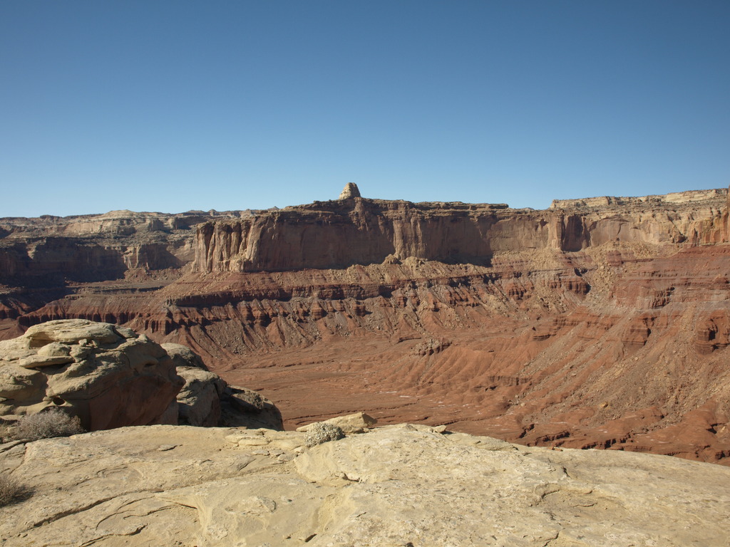
The Tomsich Butte area mines were started by John Tomsich in 1951 and are steeped in history. The area is a plethora of mining ruins, old cars, and even a lonely cabin. Mining commenced in the area during the 50's, ending in the late 50's or early 60's. Towering over Muddy Creek, Tomsich Butte proper, is a seldom visited summit with a surprisingly moderate route. The top provides outstanding views of Hondoo Arch, Muddy Creek, and the area of the Swell south of I-70.
The technical climbing is short (5 m ( 17 ft. )), but be warned, the climbing has a fair bit of loose rock. Helmets and caution are advised. The route is normally down climbed, but can be rappelled if needed. To rappel, however, you will need a 60 m ( 197 ft. ) rope, and 15 m ( 50 ft. ) of webbing. Be careful when choosing an anchor, many of the large blocks are loose.
View from the summit (looking south east)
Getting There
The easiest way to reach the trailhead is from I-70 between Green River and Salina.
- Take exit 131 from I-70 (about 30 miles west of Green River). Go south off the freeway, the road parallels the freeway for 1.8 miles before turning south. ( 12S 529696mE 4303524mN / N38° 52' 48" W110° 39' 27" )
- 3.8 - Junction stay left ( 12S 525566mE 4299454mN / N38° 50' 37" W110° 42' 19" )
- 4.9 - Junction, stay left again. ( 12S 525377mE 4297642mN / N38° 49' 38" W110° 42' 28" )
- 10.1 - Signed Junction (Reds Canyon / Tan Seep). Go right. ( 12S 522027mE 4292084mN / N38° 46' 38" W110° 44' 47" )
- 13.9 - Signed junction go right again. ( 12S 517124mE 4290141mN / N38° 45' 35" W110° 48' 10" )
- 14.8 - This is the Red Canyon / McKay Flat junction. Go right. ( 12S 515903mE 4289563mN / N38° 45' 17" W110° 49' 01" )
- From Red Canyon / McKay Flat Junction
- 1.0 - Track on the right, stay left on the main road. ( 12S 514520mE 4290171mN / N38° 45' 36" W110° 49' 58" )
- 6.8 - Another track on the right, stay on left on the main road. ( 12S 507386mE 4290562mN / N38° 45' 49" W110° 54' 54" )
- 9.1 - Junction go left again. ( 12S 505311mE 4288637mN / N38° 44' 47" W110° 56' 20" )
- 14.4 - A small track on the right with parts of an old truck. There are mining tracks going up Tomsich butte. This is the trailhead. ( 12S 501328mE 4282147mN / N38° 41' 17" W110° 59' 05" )

Tomsich from near Muddy Creek
Route
From the trailhead, and the old truck, follow the fading mining road west as it climbs. Shortly after passing a mine (10 minutes), the road splits after a large rockslide has fallen on it. Right goes down, traversing along Tomsich Butte. Go left instead, up the ever worsening mining road. At the end of the mining road, the route is directly in front of you on the hill, just right of a huge boulder. It is the only reasonable looking route.
Start by scrambling (4th class) about 5 meters to a small boulder and start of the steep section of crack. The crack protects well with a few cams from 0.5 to 1.5 inches. Once above the technical climbing, beware of knocking loose rocks down. Belay wherever is convenient, likely by a large boulder on the left.
The technical climbing is done, scramble 4th class up the loose slope to the cliff band. Once at the cliff band, go right (west) on a ledge around the corner. There is a large detached boulder that allows relatively easy access to the summit (lower 5th class). Another option is to continue on the ledge to the west side, were a slightly easier, yet very exposed path leads to the summit.
From the top, amazing views of the Swell in all directions are available.
Reverse your route.
Photos
Maps

| Trailhead |
12S 501355mE 4282386mN N38° 41' 24" W110° 59' 04" |