 Hiking The Volcano / Cosmic Ashtray
Escalante
Overview
|
Sun 79 | 47 |
Mon 80 | 51 |
Tue 79 | 51 |
Wed 76 | 49 |
Thu 70 | 47 |
| View Full Weather Details | ||||
|
Sun 79 | 47 |
Mon 80 | 51 |
Tue 79 | 51 |
Wed 76 | 49 |
Thu 70 | 47 |
| View Full Weather Details | ||||
The Volcano
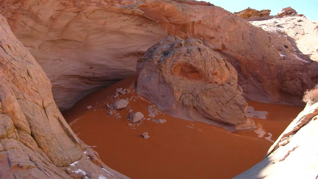
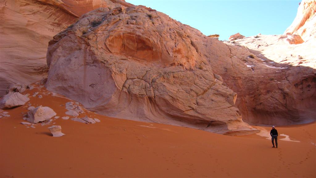
The Volcano, Cosmic Ashtray, or one of many other names is a hidden gem, with an excellent approach. The dome itself is hollow with an island in the middle. Size is difficult to grasp from pictures. Imagine a pothole 25 m ( 83 ft. ) deep, maybe 30 m + across, with a 10 m ( 33 ft. ) tall island in the middle. The bottom filled with sand dunes. Wild! If you're adventurous, the bottom of the dome can be visited.
Photographers will love both the appoach and dome itself. I'd highly recommend this outing to most, though it is brutally hot in the summer. Fall, spring, or winter would be the best times to visit.
The Volcano
Getting There
Head east out of the town of Escalante about 9.5 miles on highway 12 until you reach mile post 70. The Old Sheffield road goes off on the east side of the highway here, right on a bend.
- Reset your odometer as your turn onto the Old Sheffield road. ( 12S 460529mE 4177402mN / N37° 44' 35" W111° 26' 53" )
- Follow the generally well maintained Old Sheffield road for 5.8 miles to a junction where the main road goes right (south), and a two track road goes straight. ( 12S 467108mE 4174030mN / N37° 42' 47" W111° 22' 23" )
- Continue down the two track road 0.9 miles to a turn around spot at some slickrock. The road continues, but is closed passed this point. A side road off on the left here goes a short disance to OK primitive camping. ( 12S 468480mE 4173735mN / N37° 42' 37" W111° 21' 27" )
The Volcano Exit
Route
From the lone cedar, follow the old road down a sandy hill about 10 minutes until it trends left away from the big sandstone cliff on your right. Leave the track and follow the base of the cliff about an hour until around the point. As you follow the cliff, it becomes lower, and the steep walls give way to gentle slickrock slabs. This section has amazing views into the Escalante River canyon area.
Once around the point, head south staying at the base of the low angle slickrock slabs, with a large dome on your left. A large dome will be in view to the south (and a little west). The Volcano is at the base of the larger dome on the east side. It should take 30-40 minutes from the point to the dome. You will likely notice the old road near the dome. It appears to be the closed road that used to approach from Red Breaks.
Return the way you came.
Optional Loop: Instead of returning the way you came, you can make a bit of a loop. To do this, climb the slabs north of the dome, and work your way down and up the semi-deep side canyon on the other side. If good route finding is used, it should stay 3rd class. Once across this side canyon, head a little north and cross another shallow canyon and a divide into a 3rd canyon. Once in the third canyon, head upstream to the top of the canyon and descend slickrock back to the base of the cliffs you followed on the approach. The area above is a slickrock paradise with many neat domes, rocks, and features. Highly recommended.
Photos
Maps

| Trailhead |
12S 468994mE 4173563mN N37° 42' 32" W111° 21' 06" |
| The Volcano |
12S 472192mE 4170719mN N37° 40' 60" W111° 18' 55" |